I. Introduction
China boasts an extensive collection of stone cultural relics. As indicated by the findings of the third national cultural relics census, the country is home to a remarkable total of 24,422 grotto temples and stone carvings. Among these treasures, notable examples include the renowned Dunhuang Caves, Yungang Grottoes, and Dazu Rock Carvings, all of which stand as exceptional artistic masterpieces. Differing from other cultural artifacts, most of these relics cannot be housed within museums due to their significant size. Stone structures, in particular, having weathered the elements over prolonged periods, experience unavoidable deterioration caused by various factors. After enduring centuries of erosion, a significant number of these relics can no longer retain their original state.
To better preserve
these stone cultural relics, experts have employed various methods in studying
and restoring them to ensure their conservation. Nevertheless, as time
progresses, stone structures that have been exposed to the natural environment
for extended durations remain susceptible to inevitable deterioration due to
natural forces.
Therefore, the
precise documentation of the current state of cultural relics has become a
vital component of cultural heritage conservation. An authentic recording of
the digital information associated with cultural relics can contribute to their
perpetual existence in digital format and provide crucial support for their
conservation through measures such as deterioration monitoring and virtual
restoration. Moreover, this digital record can serve as a valuable reference
for future restoration endeavors. In contrast to conventional mapping,
photographs, and videos, three-dimensional (3D) digitization methods can record
information about cultural relics in a more extensive, comprehensive, and
precise manner. This not only facilitates the digital archiving of cultural
relics but also provides more convenient and diverse tools for conserving,
researching, and exhibiting these artifacts.
II. Background
In December 2020,
the project “China-Greece Joint Laboratory Construction and Collaborative
Research on Cultural Heritage Conservation Technology”, led by the Palace
Museum in application, received approval as part of the Strategic Scientific
and Technological Innovation Cooperation Key Project under the National Key
R&D Program. Centering on the application of advanced optical and digital
technologies such as laser cleaning, large-format hyperspectral scanning, laser
holographic speckle interference, and ultra-high-definition (UHD) 3D
digitization to fulfill the needs for conserving cultural relics in both China
and Greece, the two countries have established the China-Greece Belt and Road
Joint Laboratory on Cultural Heritage Conservation Technology, a platform
dedicated to equipment research and development, innovative applications, and
training and exchange in the field of cultural relics conservation technology.
Within this
context, the Subtopic IV titled “Research and Demonstration of
Ultra-high-definition Three-dimensional Digital Acquisition and Processing of
Stone Cultural Relics” focuses on the 3D digitization of stone cultural relics
in both China and Greece. It encompasses the exploration of a thorough
collection of basic spatial information and textural details for cultural
relics, hardware configurations, and operational procedure standardization.
With the stone
architectural components of the Palace Museum’s Lingzhao Pavilion as its
target, this sub-topic aims to delve into comprehensive cultural relic data
classification and establish a hierarchical deep-processing system with
specific criteria. By examining the particularities and disparities in UHD 3D
data acquisition and processing for cultural relics, this initiative seeks to
present a process specification and technical solution that yield consistent
outcomes with minimal manual intervention, quantifiable process and outcome
evaluation, and easy engineering implementation. Ultimately, the goal is to
establish a system for digitizing cultural relics and rules for acquisition and
processing. This, grounded in the value of cultural relics’ data, aims to meet
the requirements for heritage conservation and forward-looking exhibition and
utilization.
III. 3D Digital
Conservation of the Lingzhao Pavilion
1. Introduction to
the Lingzhao Pavilion and its Conservation
The Lingzhao
Pavilion, located within the Palace of Prolonging Happiness, or Yanxi Palace,
at the Palace Museum, is a structure crafted from metal, glass, and masonry.
Dating back to its construction in 1909, it is also known as the “Crystal
Palace”. This unique structure serves as a remarkable representation of
Western-style architecture within the Forbidden City, with only a limited number
of similar buildings in existence. Due to fire safety concerns, the pavilion
did not adopt the conventional Chinese wooden structure. Instead, it embraced a
fusion of stone and metal components, resulting in an aesthetically pleasing
and uniquely designed edifice. Embodying a characteristic Western architectural
style, it stands as an early example in China of a steel-masonry hybrid
structure that holds significant historical, artistic, and scientific
significance. Based on the site investigation, the masonry structure of the
pavilion retains a relatively intact appearance. Nonetheless, certain walls and
upper sections of window and door arches display visible cracks (Fig. 1). As
for the metal structure, while the overall appearance of the steel beams remains
relatively complete, various degrees of corrosion have occurred.
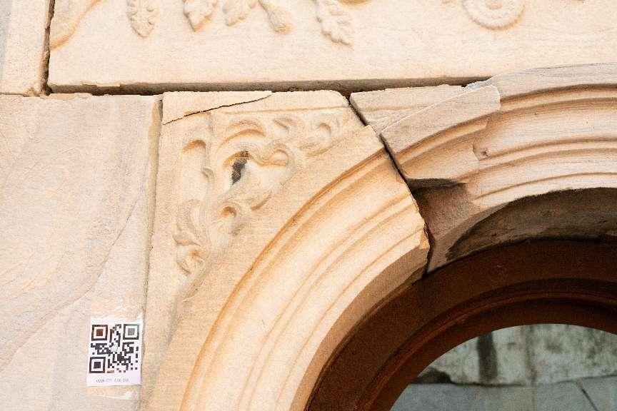
Fig. 1 Cracks in the upper sections of the door and window arches
2. 3D
Digitalization Solution
The approaches to
3D digitization for cultural relics are not standardized; they require a
comprehensive evaluation that takes into account factors like the size,
structural characteristics, and condition of deterioration of the historical
artifact. This assessment helps in selecting the appropriate method for
acquiring comprehensive information. Common techniques include 3D laser
scanning, structured-light scanning, and multi-image photogrammetric modeling,
among others. In the case of stone cultural relics, to attain a better
acquisition outcome, an independent UHD image capturing of the relic surfaces
can be employed. Additionally, there is a method to conduct UHD close-up image
acquisition, which particularly focuses on instances of deterioration. These
collaborative efforts will result in the capture of comprehensive data
including UHD, high-precision spatial information, as well as detailed textural
attributes of the cultural relics.
Building upon the
acquisition of comprehensive data from cultural relics, and guided by the
principle of digitally preserving stone cultural artifacts, this approach
involves analyzing the demands for digital preservation and exhibition and the
professional needs for preventive protection of these relics. Drawing from the
professional requirements of both aspects, a range of techniques, including
point cloud-based reverse modeling, photogrammetric modeling, virtual entity
modeling, digital image processing, and two-dimensional vector graphic
extraction, are employed to yield data outcomes spanning multiple categories
and levels for cultural relics. In this manner, a comprehensive digital
conservation system tailored to stone cultural artifacts is established.
The technology roadmap
of the UHD 3D digitization of stone cultural relics is illustrated in Fig. 2,
and the operational roadmap is delineated in Fig. 3.
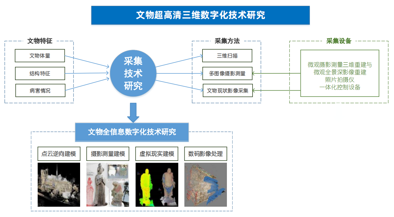
Fig. 2 The
technology roadmap of the UHD 3D digitization of stone cultural relics
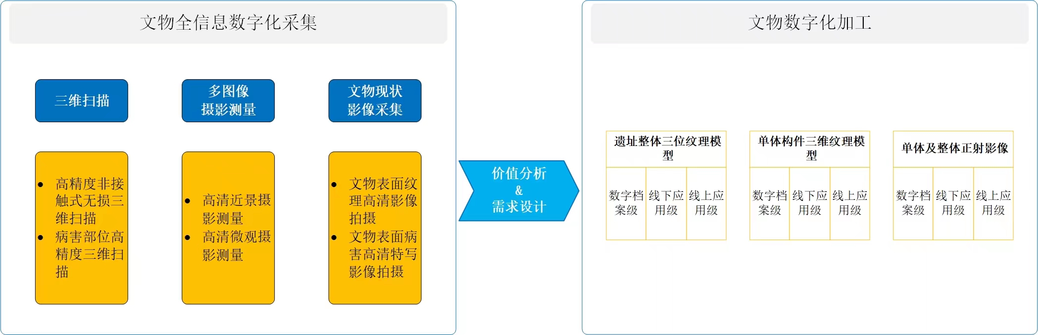
Fig. 3 The
operational roadmap of the UHD 3D digitization of stone cultural relics
3. Research on 3D Digitization Technology Methods
3.1 Data
Acquisition Methods
(1) Research on
Site-Wide Digital High-Precision Control
Establishing a
control network for site-wide digital precision control should align with the
guidelines outlined in GB50026-2020 “Standard for Engineering Surveying”. This
typically involves employing a control network adopting second-level horizontal
control surveys and fourth-level vertical control surveys to ensure that the
precision of the ground control network is sufficient to meet the requirement
for digitization. However, under restricted conditions, the process of measuring
from the points within the ground control network to the 3D scanning and
photogrammetric control points may not fully satisfy the requirements for
high-precision digitization. In the case of demonstrating the digitization of
the Lingzhao Pavilion, challenges arose when some spatial limitations and
obstructions hindered a direct line of sight for vertical surveys.
Additionally, situations occurred where a direct line of sight for vertical
surveys was possible, yet specification requirements were not met due to
exceeding limits in side length or angles. After a thorough analysis, the
single-span method using a suspended steel tape (Fig. 4) was adopted due to the
relatively low height of about twenty meters. This approach yielded the
required level of precision.
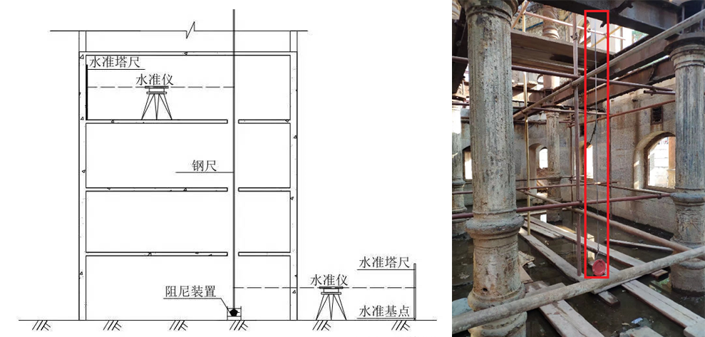
Fig. 4 Suspended
steel tape transmission
(2) Research on
Individual Component Digital High-Precision Control
Concerning the
stone components disassembled or removed from their original location, the
conventional site-wide 3D digitization control method is not appropriate in
terms of both data accuracy and operational efficiency. Through our research,
we have found that employing an integrated control approach that combines 3D
scanning and photogrammetry with the corresponding specialized device (as shown
in Fig. 5) not only guarantees precise control accuracy but also significantly
improves operational efficiency.
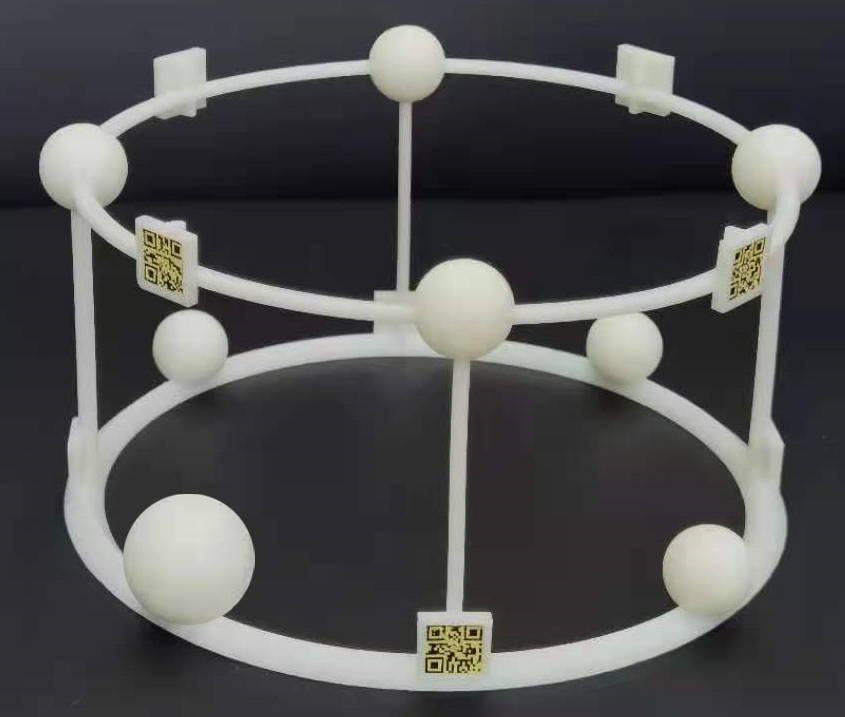
Fig. 5 The integrated 3D scanning and photogrammetry control device
When employed as a
tool for both 3D scanning and photogrammetric 3D reconstruction, the device
enables highly precise alignment between the scanning and photogrammetric mesh
models, or between the scanning point clouds and photogrammetric mesh models.
By employing these alignment methods, the achieved precision significantly
surpasses what can be accomplished through manual alignment processes. This
approach plays a pivotal role in achieving an exceptionally accurate
reproduction in the digitalization of cultural relics. Alignment tasks during
data acquisition and processing can be carried out automatically, leading to a
significant reduction in workload. This not only enhances efficiency but also
ensures that alignment outcomes remain largely unaffected by manual
intervention. When employed exclusively for photogrammetric 3D reconstruction,
the integrated device utilizes its two-dimensional codes to enable automatic
image control, eliminating the need for manually marked points. This not only
significantly enhances precision control compared to marked point-based manual
image control, but also eliminates the labor-intensive process associated with
marking points. Moreover, this approach eliminates discrepancies in control
precision arising from variations in marked points due to different operators.
When utilized solely for 3D scanning, the integrated device employs target
balls to provide control during scanning and streamline image stitching and
concatenation processes. In cases where marked points need to be applied during
scanning, they can be affixed to the frame of the device. This approach
effectively addresses the challenges arising from restrictions on attaching
marked points to cultural relics and the need to apply such points to complete
data acquisition during scanning.
The procedure for
achieving integrated control of 3D scanning and photogrammetry is outlined
below (Fig. 6).
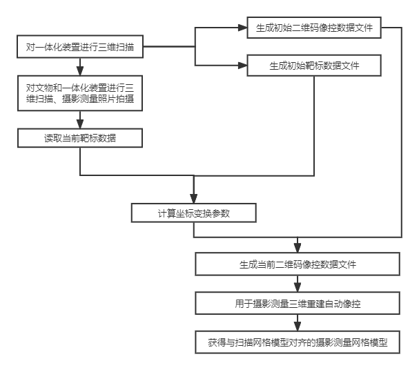
Fig. 6 The
flowchart of the integrated control of 3D scanning and photogrammetry
(3) Research on 3D
Scanning Data Acquisition
A combination of
stationary scanning and hand-held scanning techniques was employed in acquiring
the UHD 3D scanning data of the stone structures of the Lingzhao Pavilion.
In terms of stationary scanning (also known as scene scanning) for data acquisition, it was essential to determine the appropriate methods and parameters based on the specific conditions of the site. This involved a consideration of various aspects. The deployment of scanning stations entailed factors such as station distribution, scanning distances, regional coverage, indoor and outdoor spaces, depth and openings, single-story and multi-story structures, complex structures, and dead-end sections. The aspect concerning target deployment needed to be addressed as well. This included target type, target distribution, the number of targets per station, the number of shared targets among neighboring stations, alignment of targets and stations, and line of sight for control points. Additionally, scanning operations required attention to point cloud overlapping between adjacent scanning sites, accuracy and completeness of scanned data, and operational sketches.
As for hand-held
scanning (also known as close-range scanning) for data acquisition, it was
essential to determine the appropriate methods and parameters based on the
characteristics of the cultural relics. This primarily involved factors such as
target deployment, scanning direction, scanning distance, block scanning, and
the correlation between point cloud density and the shape of the cultural
relics, among others.
(4) Research on
Photogrammetric Data Acquisition
Close-range
photogrammetry was employed in acquiring the UHD 3D data of the stone
structures of the Lingzhao Pavilion. The acquisition process required careful
consideration of the specific conditions to determine suitable methods and
parameters. This included factors like photo resolution, control point
deployment, lighting conditions during photography, longitudinal overlap,
lateral overlap, the number of neighboring photographs, and color reproduction
management, among others.
3.2 Data Processing
Methods
(1) Research on 3D Scanning Data Processing
In order to archive and process the point cloud data acquired through the UHD 3D scanning of the Lingzhao Pavilion, it was crucial to select the appropriate methods and parameters guided by the characteristics of the data. This process primarily encompassed point cloud stitching and error correction, coordinate system conversion, exclusion of non-target point clouds, elimination of abnormal point clouds, noise reduction within the point clouds, thinning of the point clouds, creation of mesh models, and elimination of overlapping and intersecting surfaces.
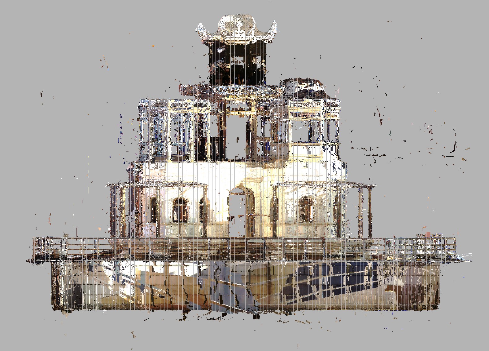
Fig. 7 The scene scanning result
(2) Research on
Photogrammetric Data Processing
In order to archive
and process the data acquired through 3D reconstruction using the UHD 3D
photogrammetric images of the Lingzhao Pavilion, it was crucial to identify the
appropriate methods and parameters in accordance with the data. This process
encompassed various steps, such as excluding substandard photographs, restoring
photo colors, conducting aerotriangulation, generating texture models,
eliminating overlapping and intersecting surfaces and seams in mesh models,
rectifying blurring, stretching, seams, and highlights in texture mapping,
achieving color balancing and dodging in texture mapping, eliminating
fragmented UV maps, and optimizing both the mesh models and the quantity of
mapped data.
(3) Research on
Integrated 3D Scanning and Photogrammetric 3D Reconstruction Data Processing
In order to
archive and process the data acquired by combining the point clouds acquired
during high-definition 3D scanning and 3D reconstruction using the
photogrammetric images of the Lingzhao Pavilion, it was essential to determine
the appropriate methods and parameters that aligned with the specific data.
This process entailed various steps, encompassing distinct procedures for both
3D scanning data processing and photogrammetric data processing. Additionally,
it involved the segmentation and unwrapping of the 3D scanning mesh model for
UV mapping, evaluating discrepancies between the photogrammetric and 3D
scanning mesh models, and baking texture mapping from the photogrammetric
texture model to the 3D scanning mesh model.
4. High-Precision
3D Digitization Outcomes of the Lingzhao Pavilion
Following the
criteria of UHD 3D digitization for stone cultural relics in control surveying,
and considering the specific attributes of the pavilion, precise control
measurements were executed. This encompassed the establishment of a ground
control network and the positioning of scene-specific control points for both
3D scanning and photogrammetry. The data gathered from each measurement
demonstrated conformity with the prescribed criteria.
The integration of
scene-based 3D scanning with hand-held 3D scanning yielded the following data
(Table 1):
Table 1 Statistics for 3D point cloud data
|
3D point cloud |
Number of points |
394,639,253 |
|
Original single-station spacing |
0.6 mm |
|
|
The overall error between point clouds |
2.78 mm |
|
|
Point cloud data size after stitching |
22.1 G |
Close-range
photogrammetry yielded the following data (Table 2):
Table 2 Statistics for photogrammetric data
|
Photogrammetry |
Number of photographs |
122,008 photos |
|
Photographic data size |
8.77 T |
Experimental
processing was carried out on stone components using UHD resolutions of 4K, 8K,
12K, and 16K, resulting in the following model:
The data
processing sample of the stone component of the Lingzhao Pavilion


website: www.dpm.org.cn